
Geographic data plays a crucial role in understanding a data model, offering valuable insights. By utilizing geographic data to map and segment information based on spatial distribution, it provides a fresh perspective on observed trends within your dataset. At WeQan, we leverage powerful geographic data visualization tools to present key concepts in a clear and impactful manner, empowering effective decision-making and strategic planning.
Qlik Sense GeoAnalytics is the extension that enables you to perform these operations within Qlik Sense. It offers a wide range of advanced functionalities for geospatial data analysis. Businesses with access to geographic data such as addresses, postal codes, or GPS coordinates can leverage these tools to map, visualize, and analyze locations, regions, extents, and configurations.
GeoAnalytics environment
The GeoAnalytics Environment This environment offers three types of tools:
- Generic functions that facilitate transforming your database for optimal utilization within Qlik.
- Geospatial GeoOperation functions, such as Route, which enable the generation of routes along road networks. Intersect and Within allow for analyzing the relationship between different geometric structures.
- Aggregation-type GeoOperation functions, including Binin, assist in consolidating data and creating aggregated geographic zones like grids, density polygons, hexagons, and other representations that encapsulate data on a broader scale.
One of the notable advantages of this tool is its ability to generate supplementary data, such as distance, travel duration, and various consolidations. These additional insights can be directly incorporated into your ETL (Extract, Transform, Load) process.
Practical Applications:
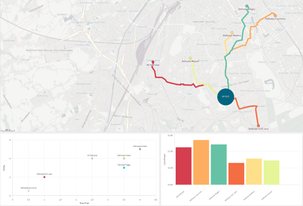
Let’s consider a practical example where your internal service department aims to procure nearby supplies for its offices. By utilizing the Route and Closest GeoOperation functions, you can swiftly calculate the stores that offer specific products. Furthermore, these functions provide valuable information on travel duration and time, which can be seamlessly integrated into your dataset and visualizations.
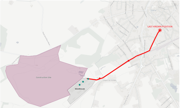
The Within and Route functions can be utilized to create a geofencing solution. Let’s say your machinery is equipped with a GPS system. You can seamlessly integrate this geolocation data and cross-reference it with your warehouse or construction site data to ensure proper utilization of your equipment.
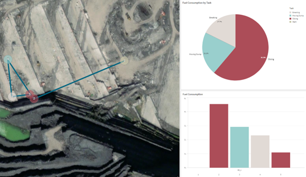
By combining GeoAnalytics with Qlik Alerting, you will receive immediate alerts regarding any abnormal usage of your machinery.
During the working phase, you can consolidate the data from these machines and analyze each workstation (duration, fuel consumption, etc.)
Conclusion
In conclusion, GeoAnalytics is a powerful and versatile solution that allows you to develop personalized applications tailored to your needs. Furthermore, it is available for free in the Qlik Sense Cloud offering.
Follow our news :
See you soon !

![]()
![]()
![]()